Harlan
Township
1875 |
|
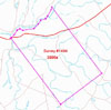
Virginia Military
District Survey #764 [back to top]
| Survey # |
Name |
Description |
| |
|
|
|
|
Harlan
Township
1875 |
|
Virginia Military District Survey
#980 [back to top]
| Survey # |
Name |
Description |
| |
|
|
|
|
Harlan
Township
1875 |
|
Virginia Military
District Survey #1032 [back to top]
| Survey # |
Name |
Description |
| |
|
|
|
|
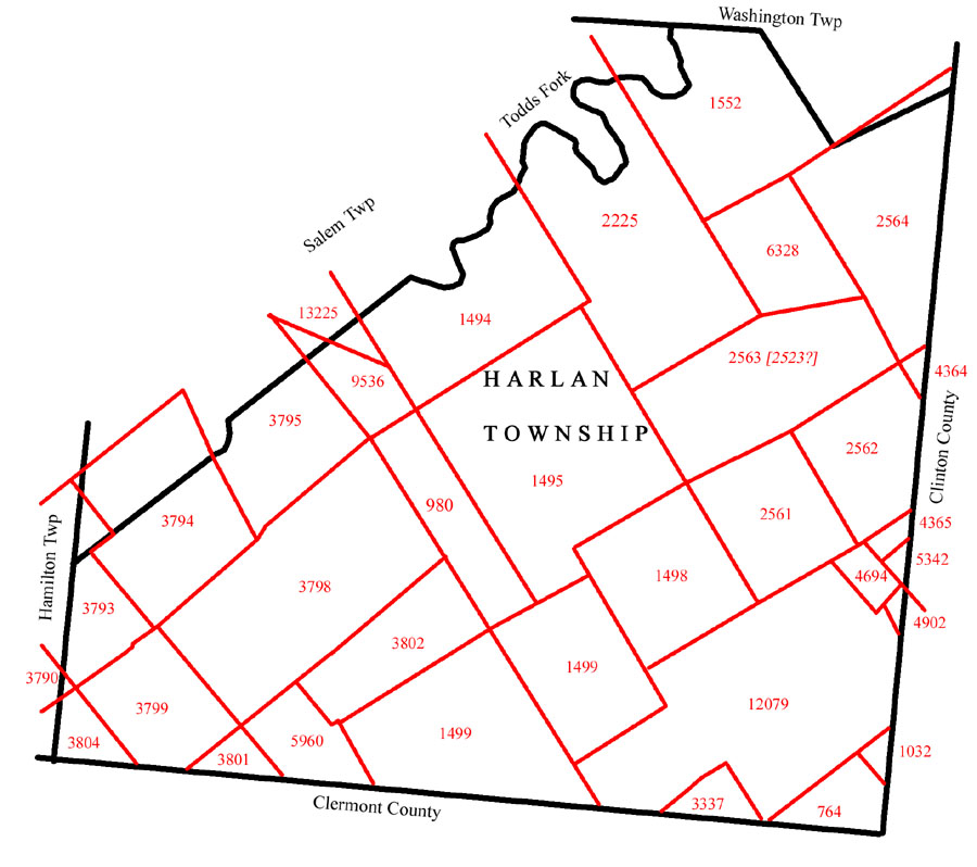
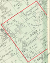
Harlan
Township
1875
plat of 1798 patent
|
|
Virginia Military District Survey
#1494 - extends into Salem Twp [back
to top]
Military
Bounty Land Warrant #171 issued to John
Peyton Harrison (a Captain for three years) to the United States,
in the Virginia Line of Continental Establishment.
Patent granted to Burr Powell assignee of the said John Payton Harrison
on 9 Jun 1798 for a certain tract of land containing four thousand acres,
situate between the little Miami and Sciota Rivers, north-west of the River
Ohio, as by survey bearing the date the tenth day of October in the year
one thousand seven hundred and ninety two and bounded and described as follows,
to wit, Survey of four thousand acres of land on a military warrant number
one hundred and seventy one, in favor of the said John Peyton Harrison for
a like quantity, on the east side of the Little Miami
Beginning at a honey locust, buckeye and sugartree marked No. 3, honey locust
WE another M on the upper side of the mouth of Todd’s fork which empties
in the Miami about twenty five miles from the Ohio, thence up the River
North forty three degrees east fifty four poles, north thirty two degrees
east sixty poles, north sixty one degrees east thirty eight poles, south
sixty five degrees east forty four poles, north eighty one degrees east
one hundred thirty eight poles, north forty four degrees east seventy eight
poles, north thirty one degrees east fifty four poles, north seventy two
degrees east sixty eight poles, north thirty seven degrees east forty poles,
north twenty nine degrees east eighty eight poles, north sixteen degrees
east thirty six poles to Burr & white oaks on the bank of the river,
thence south thirty seven degrees east one thousand and thirty two poles
crossing branches at eighty and one hundred and fourteen poles, Todd’s
Fork at six hundred and ten poles, branch at seven hundred and fifty eight
poles to three dogwoods & black oak,
thence south fifty three degrees west six hundred & forty poles crossing
four branches at one hundred & 10,three hundred and eighty, four hundred
& seventy four & five hundred & sixty poles to two white oaks
& hickory,
thence north thirty seven degrees west one thousand & thirty two poles
to the beginning.
| Survey # |
Name |
Description |
| |
|
|
|
|
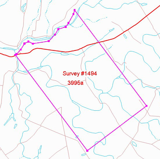
Harlan
Township
1875

plot of 1803 patent
|
|
Virginia Military District Survey
#1495 [back to top]
Military
Bounty Land Warrant #2843 issued to
Roger Nelson (a Lieutenant for the War) to the United States,
in the Virginia Line on Continental Establishment.
Patent granted to Roger Nelson on 11 Oct 1803 for a certain
tract of land, containing two thousand six hundred sixty six and two thirds
acres of land situate between the little Miami and Sciota Rivers, north-west
of the river Ohio, as by survey, bearing date the tenth day of October in
the year one thousand seven hundred and ninety two and bounded and described
as follow, To Wit Survey for Roger Nelson Two Thousand
six hundred sixty six and two thirds acres of land on two Military Warrants,
to Wit: On No. 2843 for one thousand acres in favor of the said Roger
Nelson; and on No. 2844 for one thousand six hundred sixty six
& two thirds acres, in favor of the said Roger Nelson;
on the waters of Todds fork a Branch of the Little Miami, Beginning at four
white oaks South corner to John P. Harrison’s Survey
No. 1494, thence with his line North fifty three degrees East six hundred
and forty pole crossing four branches at eighty poles, one hundred and sixty
six poles, two hundred and sixty poles, and five hundred and thirty poles
to three dogwoods and a black Oak East corner to said Harrison, thence South
thirty seven degrees East six hundred sixty six and two thirds poles crossing
a branch at five hundred and thirty poles and six hundred and two poles
to three white oaks, thence south fifty three degrees west six hundred and
forty poles to three hickories, thence north thirty seven degrees west six
hundred sixty six and two thirds poles to the Beginning.
| Survey # |
Name |
Description |
| |
|
|
|
|
Harlan
Township
1875

plot of 1802 patent
|
|
Virginia Military District Survey
#1498 [back to top]
Military
Bounty Land Warrant No. 1416 issued to Peyton Powell,
a Lieutenant for three years to the United States, in the Virginia Line
on Continental Establishment.
Patent granted unto John Wise, assignee of said Peyton
Powell on 23 Jan 1802 for a certain tract of land containing 1,000
acres situate between the little Miami and Sciota Rivers, north-west of
the River Ohio, as by survey bearing date the Sixteenth day of April in
the year one thousand eight hundred and bounded and described as follows,
to wit, Survey of 1,000 acres of land on a Military Warrant Number one thousand
four hundred and sixteen, in favor of the said Peyton Powell
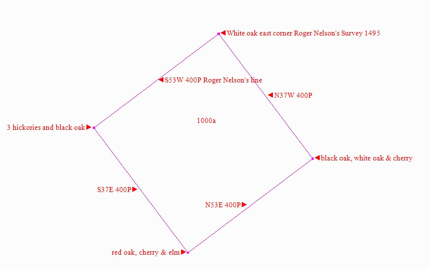
for a like quantity on the waters of Tod's fork, Beginning at three white
oaks east corner to Roger Nelson's Survey
No. 1495, thence with his line South fifty three degrees west four hundred
poles to three hickories and a black oak in the line of said Nelsons survey,
thence south thirty seven degrees east four hundred poles to a Red Oak,
Cherry Tree and Elm, thence north fifty three degrees east four hundred
poles to a black oak white oak and hickory thence north thirty seven degrees
west four hundred poles to the beginning.
| Survey # |
Name |
Description |
| |
|
|
|
|
Harlan
Township
1875

plot of 1807 patent
|
|
Virginia Military District Survey
#1499 - East [back to top]
2 surveys marked with #1499 - this is the east survey
Military
Bounty Land Warrant #2957 issued to Rodham Moxly, a
subaltern for three years to the United States, in the Virginia Line on
Continental Establishment.
Patent granted to William Moxly and William Ellzey
on 21 Mar 1807 for a certain tract of land, containing one thousand one
hundred sixty six & two thirds acres situate between the little Miami
and Sciota Rivers, north-west of the River Ohio, as by survey, bearing date
the twentieth day of September in the year one thousand eight hundred and
six, and bounded and described as follows, To Wit, Surveyed for William
Moxly one thousand one hundred sixty six and two thirds acres of
land on part of a Military Warrant No. 2957 in favor of William
Moxly heir at law of the said Rodham Moxly deceased
(the whole thereof being for two thousand six hundred sixty six and two
thirds acres) on the waters of the Little Miami; Beginning at three hickories
and a large black oak west corner to John Wise’s
survey No. 1498 in the line of Roger
Nelson’s Survey No. 1495
running with Nelson Line passing his corner at 240 poles S53 W 534 poles
to a stake, corner of John and Charles Binns survey of
1500 acres, thence with their line S 37 E 534 poles to a stake East corner
to said Binns survey, thence N53 E 350 poles to a black oak, thence N 37
W 534 poles passing said Wises south corner at 134 poles and with the same
to the beginning.
The said William Moxly having assigned three hundred sixty
six and two thirds acres of the above survey to William Ellzey,
viz: Beginning at the beginning corner of the survey thence with the first
course thereof to the second corner, thence along the second line S37E 167
29/35 poles, thence across the tract parallel to the first course N 53 E
350 poles to the last line of the survey, thence with that line to the beginning.
| Survey # |
Name |
Description |
| |
|
|
|
|
Harlan
Township
1875

plot of 1807 patent
|
|
Virginia Military District
Survey #1499 - West [back to top]
2 surveys marked with #1499 - this is the west survey
Military
Bounty Land Warrant #2957 issued to
Rodham Moxly, a subaltern for three years to the United States, in the Virginia
Line on Continental Establishment.
Patent granted to Charles Binn assignees as to one ___
of John Binns the said Charles Binns &
John Binns being joint assigness of William Moxly
heir at law of the said Rodham Moxly on 21 Mar 1807 for
a certain tract of land, containing one thousand five hundred acres situate
between the little Miami and Sciota Rivers, north-west of the River Ohio,
as by survey, bearing date the twentieth day of September in the year one
thousand eight hundred and six, and bounded and described as follows, To
Wit, Surveyed for John & Charles Binns one thousand
five hundred acres of land one part of Military Warrant No. 2957, in favor
of William Moxly heir at law of the said Rodham
Moxly (the whole thereof being for two thousand six hundred sixty
six and two thirds acres) on the waters of the Little Miami beginning at
a stake west corner to William Moxly’s Survey
No. 1499 for 1166 2/3 acres running S 53 W 450 poles to two white oaks,
thence S 37 E 534 poles to a sugar tree and white oak, thence N 53 E 450
poles to a stake south corner to said Moxly’s survey, thence with
his line N 37 W 534 poles to the beginning.
| Survey # |
Name |
Description |
| |
|
|
|
|
Harlan
Township
1875 |
|
Virginia Military District Survey
#1552 [back to top]
| Survey # |
Name |
Description |
| |
|
|
|
|
Harlan
Township
1875 |
|
Virginia Military District Survey
#2225 [back to top]
| Survey # |
Name |
Description |
| |
|
|
|
|
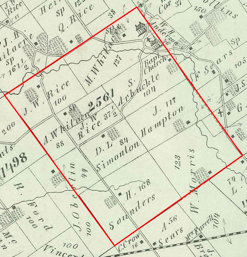
Harlan
Township
1875 |
page 59
1000 acres |
Virginia Military
District Survey #2561 [back to top]
General
Land Office Patent issued to John Fitzgerald, a Major
for three years in the Virginia Line on Continental Establishment
Know Ye, that in consideration of military
service performed by John Fitzgerald, a Major for three
years, to the Unites States, in the Virginia Line on Continental Establishment,
and in pursuance of an Act of the Congress of the United States, passed
on the 10th day of August, in the year 1790, intituled “An act to
enable the Officers and Soldiers of the Virginia Line on Continental Establishment
to obtain titles to certain lands lying north west of the River Ohio, between
the Little Miami and Sciota;” and another Act of the said Congress
passed on the 9th day of June, in the year 1794, amendatory of the said
Act, there is granted by the said Unites States unto Frances Fitzgerald,
John Diggs Fitzgerald, Jane Fitzgerald,
now the wife of Francis L. Lee, William Atwood
Fitzgerald & George Richard Fitzgerald heirs
and devises of the said John Fitzgerald
a certain tract of land, containing One thousand acres situate between the
little Miami and Sciota Rivers, north west of the River Ohio, as by survey,
bearing date the twenty fifth day of June in the year one thousand seven
hundred and ninety five, and bounded and described as follows, To Wit: Survey
of One thousand acres of Land on part of a Military
Warrant No. 2868, in favor of the said John Fitzgerald,
(the whole thereof being for Five thousand three hundred and thirty three
and one third acres) on the water of Todd’s fork, a branch of the
little Miami, beginning at three white oaks, East corner to Roger
Nelson’s survey No. 1495; thence N53E
400 poles to a black oak and hickory; thence S37E 400 poles, crossing a
branch at 90 poles a large branch at 200 poles to three white oaks; thence
S53W 400 poles, crossing a large branch at 40 poles to a black oak, white
oak and hickory; thence N37W 400 poles to the beginning,
with all appurtenances: To have and to hold the said tract
of land with the appurtenances, unto the said Frances, John Diggs,
Jane, William Atwood & George Richards Fitzgerald and their
heirs and assigns forever, as Tenants in common and not as joint Tenants:
In witness whereof, The said James Madison
President of the United States of America, hath caused the seal of the General
Land Office to be hereunto affixed, and signed the same with his hand at
the City of Washington, the nineteenth day of October in the year of our
Lord one thousand eight hundred and twelve and of the Independence of the
United States of America, the thirty seventh.
By the President, James Madison {signature}
Edward Tiffin {signature} Commissioner of the General Land
Office.
20 Feb 1813 delivered Thomas Diggs Esq.
Click
here for image of 2 Apr 1784 Certificate
for Bounty Land Warrant No. 2868
| Survey # |
Name |
Description |
| 2561 |
S. Arbuckle |
104 acres |
| 2561 |
Bapt. Church |
Lot |
| 2561 |
Cemetery |
Lot [New Hope Cemetery] |
| 2561 |
J. Hampton |
117 acres [partly in Survey #2562] |
| 2561 |
W. Morris |
123 acres [extends into Survey #4694] |
| 2561 |
J. Oberlin |
44 acres [extends into Survey #1498] |
| 2561 |
J. W. Rice |
100 1/2 acres |
| 2561 |
J. W. Rice |
37 1/2 acres |
| 2561 |
School |
Lot [known as New Hope School] |
| 2561 |
D. L. Simonton |
84 acres |
| 2561 |
H. Sounders |
168 acres |
| 2561 |
A. W. Whitacre |
88 acres |
| 2561 |
M. Whitacre |
127 acres |
|
by
Arne
H Trelvik
9 May 2016 |
Harlan
Township
1875 |
1000 acres |
Virginia Military District Survey
#2562 - extends into Clinton County [back
to top]
General
Land Office Patent issued to John Fitzgerald, a Major
for three years in the Virginia Line on Continental Establishment
Know Ye, That, in consideration of
military service performed by John Fitzgerald, a Major
for three years to the Unites States in the Virginia Line on Continental
Establishment to obtain titles to certain lands lying north west of the
River Ohio, between the little Miami and Sciota;” and another Act
of the said Congress, passed on the 9th day of June in the year 1794, amendatory
of the said Act, there is granted by the said United States unto Frances
Fitzgerald, John Diggs Fitzgerald, Jane
Fitzgerald, now the wife of Francis L. Lee, William
Atwood Fitzgerald & George Richards Fitzgerald
heirs and Devises of the said John Fitzgerald
a certain tract of land, containing one thousand acres situate between the
little Miami and Sciota Rivers, north west of the River Ohio, as by survey,
bearing date the twenty sixth day of June in the year one thousand seven
hundred and ninety five, and bounded and described as follows, To Wit: Survey
of one thousand acres of Land on part of a Military
Warrant No. 2868, in favor of the said John Fitzgerald
(the whole thereof being for five thousand three hundred and thirty three
and one third acres) on the waters of Todd’s fork, a branch of the
little Miami, beginning at a black oak and hickory, North corner to said
Fitzgeralds survey No. 2561; thence with his lines
S37E 400 poles, crossing a large branch at 2oo poles, and a branch at 90
poles, to three white oaks, East corner to Said Fitzgeralds; thence N53E
400 poles to two hickories and a black gum; thence N37W 400 poles to a white
oak and sugar tree; thence S53W 400 poles crossing a large branch at 12
poles to the beginning,
with the appurtenances: To Have and to hold the said tract
of land with the appurtenances, unto the said Frances, John Diggs,
Jane, William Atwood & George Richard Fitzgerald and their
heirs and assigns forever, as Tenants in common and not as joint Tenants:
In Witness whereof, the said James Madison President of
the Unites States of America, hath caused the seal of the Genl Land Office
to be hereunto affixed, and signed the same with his hand at the City of
Washington, the nineteenth day of October, in the year of our Lord one thousand
eight hundred and twelve; and of the Independence of the United States of
America, the thirty seventh.
By the President, James Madison {signature}
Edward Tiffin {signature}, Commissioner of the General
Land Office
Click
here for image of 2 Apr 1784 Certificate
for Bounty Land Warrant No. 2868
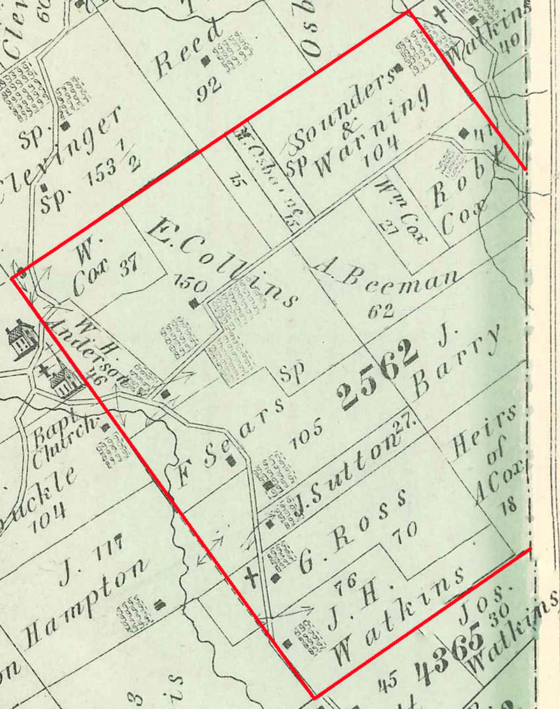
| Survey # |
Name |
Description |
| 2562 |
[no name listed] |
15 acres |
| 2562 |
W. H. Anderson |
46 acres |
| 2562 |
J. Barry |
[no acreage listed - extends into Clinton County] |
| 2562 |
A. Beeman |
62 acres |
| 2562 |
cemetery |
lot [West Mary Cemetery] |
| 2562 |
E. Collins |
150 acres |
| 2562 |
A. Cox heirs |
18 acres [extends into Clinton County] |
| 2562 |
Robt. Cox |
47 acres |
| 2562 |
W. Cox |
37 acres |
| 2562 |
Wm. Cox |
27 acres |
| 2562 |
M. Osborne |
15 acres |
| 2562 |
G. Ross |
70 acres |
| 2562 |
F. Sears |
105 acres |
| 2562 |
Sounders & Warning |
104 acres |
| 2562 |
J. Sutton |
27 acres |
| 2562 |
J. H. Watkins |
76 acres |
|
|
Harlan
Township
1875 |
|
Virginia Military
District Survey #2563 [MS
#2523 on current day G.I.S. map] [back
to top]
| Survey # |
Name |
Description |
| |
|
|
|
|
Harlan
Township
1875 |
|
Virginia Military
District Survey #2564 [back to top]
| Survey # |
Name |
Description |
| |
|
|
|
|
Harlan
Township
1875 |
|
Virginia Military District Survey
#3337 [back to top]
| Survey # |
Name |
Description |
| |
|
|
|
|
Harlan
Township
1875 |
|
Virginia Military
District Survey #3793 -
also see parcels in Salem Township and in Hamilton
Township [back to top]
| Survey # |
Name |
Description |
| |
|
|
|
by
Arne
H Trelvik
20 March 2007 |
Harlan
Township
1875 |
|
Virginia Military District Survey
#3794 - extends into Salem Township [back
to top]
| Survey # |
Name |
Description |
| |
|
|
|
by
Arne
H Trelvik
25 Jul 2007 |
Harlan
Township
1875 |
|
Virginia Military District Survey
#3795- extends into Salem Township [back
to top]
| Survey # |
Name |
Description |
| |
|
|
|
|
Harlan
Township
1875 |
|
Virginia Military District
Survey #3798 [back to top]
| Survey # |
Name |
Description |
| |
|
|
|
|
Harlan
Township
1875 |
|
Virginia Military District Survey
#3799 [back to top]
| Survey # |
Name |
Description |
| |
|
|
|
|
Harlan
Township
1875 |
|
Virginia Military
District Survey #3801 - extends into Clermont County
[back to top]
| Survey # |
Name |
Description |
| |
|
|
|
|
Harlan
Township
1875 |
|
Virginia Military District Survey
#3802 [back to top]
| Survey # |
Name |
Description |
| |
|
|
|
|
Harlan
Township
1875 |
|
Virginia Military District Survey
#3804 - extends into Hamilton Twp and into Clermont County [back
to top]
| Survey # |
Name |
Description |
| |
|
|
|
|
Harlan
Township
1875 |
|
Virginia Military
District Survey #4364 [back to top]
530 acres total - mostly in Clinton County, Ohio
| Survey # |
Name |
Description |
| |
|
|
|
|
Harlan
Township
1875 |
|
Virginia Military District Survey
#4365 [back to top]
| Survey # |
Name |
Description |
| |
|
|
|
|
Harlan
Township
1875 |
|
Virginia Military District Survey
#4694 [back to top]
| Survey # |
Name |
Description |
| |
|
|
|
|
Harlan
Township
1875 |
|
Virginia Military District Survey
#4902 [back to top]
| Survey # |
Name |
Description |
| |
|
|
|
|
Harlan
Township
1875 |
|
Virginia Military
District Survey #5342 [back to top]
| Survey # |
Name |
Description |
| |
|
|
|
|
Harlan
Township
1875 |
|
Virginia Military District Survey
#5960 [back to top]
| Survey # |
Name |
Description |
| |
|
|
|
|
Harlan
Township
1875 |
|
Virginia
Military District Survey #6328
including Edwardsville Cemetery
[back to top]
Edwardsville Road runs diagonally from the SW to NE part
of the map. Kunker Road runs from Osceola to Edwardsville
Road. Middleboro Road runs southeast from Middleboro.
| Survey # |
Name |
Description |
| |
|
|
|
|
Harlan
Township
1875 |
|
Virginia Military District
Survey #9536 [#9536 on current maps]
extends into Salem Township [back to
top]
Mislabeled
on the map as Survey #9556
| Survey # |
Name |
Description |
| |
|
|
|
|
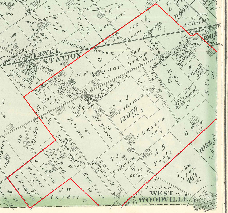
Harlan
Township
1875 |
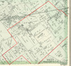
1,980 2/3 acres |
Virginia Military District
Survey #12079 - extends into both Clinton County and Clermont County [back
to top]
Virginia Military Surveys, Warren County, Ohio, page
123
Surveyed for Samuel I. Cabell, James
Taylor, assn William L. Pierce, Simon
Somers, William Porter, Alexander Brickenridge,
the Representatives of William Miller and John
Beale 1,980 2/3 acres of land on the following Military warrants,
Cabell and Taylor 833 1/3 acres on No.
5334, Pierce 166 2/3 acres on No. 5858, Somers
166 2/3 acres on No. 6198, Porter 200 acres on No. 6109,
Breckenridge 550 acres on No. 617 Miller’s
Repts 50 acres on No. 5489 and Beale 14 acres
on No. 1348 on the waters of the Little Miami
Beginning at a gum maple and elm, northerly corner to William
Pierces survey No. 9532, in the line of John and Charles
Binn’s survey No. 1499; thence with
their line and the line of William Moxleys survey
No. 1499 N52 ½ E 510 poles passing Binn’s and Moxley’s
corner to a black oak East corner to Moxley’s said survey; thence
with another of his lines N38W 125 poles to a red oak cherry tree and
elm south corner to John Binn’s survey No. 1798;
thence with his line and the line of John Fitzgerald’s
survey No. 2561, N52 ½ E 503 poles crossing
a branch of Todd’s Fork to a white oak and two dogwoods in said
line westerly corner to J. Parker’s survey
No. 4594; thence with his line S45E 154 poles crossing a branch to
two dogwoods and a hornbeam southerly corner to Parker’ thence with
another of his lines N45E 30 poles to two hickories westerly corner to
survey No. 4902; thence with a line of said survey
and survey No. 9009 S41E 215 poles crossing a branch to three hickories
and a maple in the line of Holman Minnes’ survey
No. 1032; thence with his line and the line of Andrew Epples
survey No. 764 S46 ½ W 600 poles to a hickory
elm and white oak westerly corner to said survey in the line of Harvie
and Finn’s survey No. 3337; thence with their line N45W
170 poles crossing a branch of Stone-lick creek to a red oak hickory and
ash, northerly corner to said survey; thence with another of their lines
S45W 400 poles to two elms and a maple corner to said Pierce’s
survey; thence with his line N45W 215 poles to the beginning.
James Taylor D.S. [deputy surveyor]
December 24th 1822
February 12th 1823
Jefferson Talliaferro & Anthony Moore
C.C. [chain carriers]
Samuel Winitore M. [marker]
| Survey # |
Name |
Description |
| 12079 |
J. Brown |
20 acres |
| 12079 |
J. Brown |
28 acres |
| 12079 |
James Brown |
45 acres |
| 12079 |
Jehu Brown |
85 acres |
| 12079 |
Mrs. Brown |
70 acres |
| 12079 |
P. Brown |
21 acres |
| 12079 |
R. Brown |
6 acres |
| 12079 |
Vincent Brown |
78 acres |
| 12079 |
Cemetery |
Lot [Wesley Chapel Cemetery] |
| 12079 |
J. Coleman |
Lot |
| 12079 |
A. Cox |
30 acres |
| 12079 |
C. Crow |
16 acres |
| 12079 |
E. Engle |
13 acres |
| 12079 |
D. Farquar |
127 acres |
| 12079 |
Mrs. Farrell |
Lot |
| 12079 |
A. B. Foote |
108 acres |
| 12079 |
W. Foote |
41 acres |
| 12079 |
A. Fox |
74 1/2 acres |
| 12079 |
D. Fox |
105 acres |
| 12079 |
J. M. Fox |
83 acres |
| 12079 |
J. M. Fox |
63 acres |
| 12079 |
A. Greeley |
Lot |
| 12079 |
S. Gustin |
146 1/2 acres |
| 12079 |
F. Hawthorne |
1 acre |
| 12079 |
J. M. Jackson |
|
| 12079 |
T. Jones |
160 acres |
| 12079 |
T. Jones |
60 acres |
| 12079 |
J. Jordan |
115 acres [mostly in Survey #764] |
| 12079 |
Ben Lever |
96 acres |
| 12079 |
H. Liggett |
34 acres |
| 12079 |
J. Liggett |
20 acres |
| 12079 |
F. Little |
Lot |
| 12079 |
M. E. Church |
Lot [Wesley Chapel Methodist
Episcopal Church] |
| 12079 |
Mrs. Miller |
11 acres |
| 12079 |
W. Morris |
104 acres |
| 12079 |
J. Osborne |
Lot |
| 12079 |
U. Osborne |
|
| 12079 |
T. J. Patterson |
34 acres |
| 12079 |
T. J. Patterson |
178 acres |
| 12079 |
T. J. Patterson |
130 10/16 acres |
| 12079 |
John Prickett |
67 acres |
| 12079 |
T. Rohmor |
40 acres |
| 12079 |
T. Rollins |
11 acres |
| 12079 |
G. Runyan |
75 acres |
| 12079 |
N. Scott |
48 acres |
| 12079 |
A. Sears |
56 acres |
| 12079 |
M. Sears |
100 acres |
| 12079 |
John Sharp |
150 acres [extends into Survey #1499 |
| 12079 |
A. Williams |
70 acres |
| 12079 |
A. Williams |
38 acres |
| 12079 |
J. Wolf |
10 acres |
|
|
Harlan
Township
1875 |
|
Virginia Military
District Survey #13225[#9536 on current maps]
extends into Salem Township [back to
top]
| Survey # |
Name |
Description |
| |
|
|
|
|
| |
|
|
|